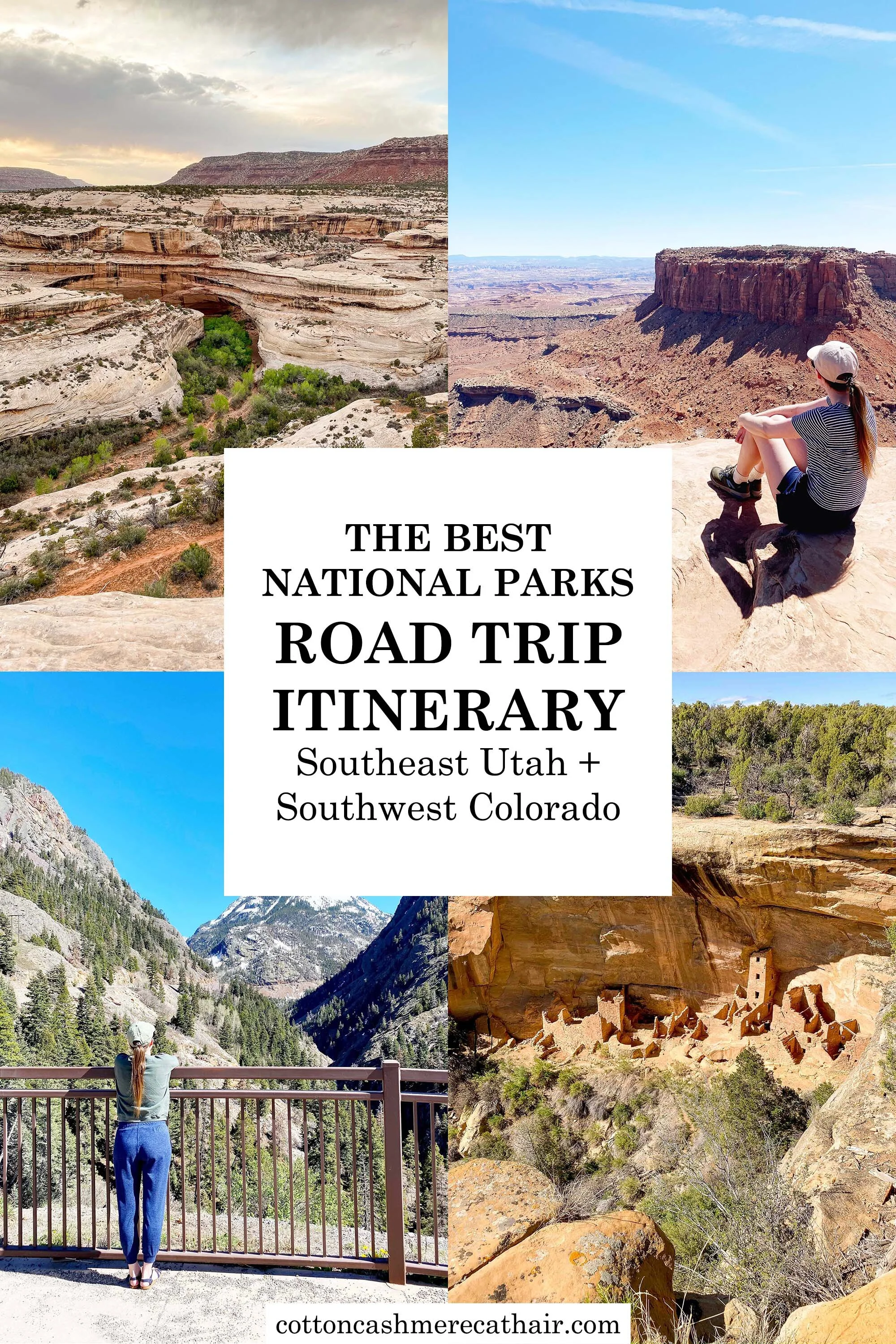
Southeast Utah and Southwest Colorado National Parks Road Trip Itinerary
Instead of flying down to Colorado with the rest of my family to attend my brother’s college graduation last month, Korri and I went on a long road trip (the “scenic route”) through southeast Utah and southwest Colorado, hitting up a bunch of national parks and monuments along the way. This was a trip I’d been wanting to do ever since I learned my brother would be going to college in Colorado, and I’m so happy we were able to make it happen (with lots of COVID precautions!).
Here’s our 9-day national parks road trip itinerary through southeast Utah (the Moab area) and southwest Colorado (the Cortez and Grand Junction areas). (I left out the 3 days we spent with my family, celebrating my brother’s graduation.) I would LOVE to do this trip again; it was kind of a whirlwind trip and we were so exhausted after hiking and driving this much, but it was doable and we made it work because there’s so much to see! You gotta at least add these destinations to your travel list! I plan to write more blog posts about the individual parks in the coming months, too.
If you do plan to do this road trip or one like it, be sure to pick up an Interagency Annual Pass for $80—this will get you entry into all of these parks (and all of the others) for a full year! Each park entry is $30 per vehicle if you do not have a pass, so the pass pays for itself if you go to only three parks.
Southeast Utah National Parks Road Trip
DAY 1: Drive from Boise to Moab, Utah
This was a long day and we got a very late start, which meant we got into Moab really late (it’s about a 8.5-9 hour drive). We stopped at Lucky Slice in historic downtown Ogden for slices of pizza and at Cubby’s in Spanish Fork for their amazing fries (Spanish Fork is anti-maskers’ paradise, so I’d maybe try to avoid stopping here if you can until it’s really safe; this was before the CDC changed their face mask guidance). These are two of our favorites places to eat at anytime we’re in Utah and we highly recommend both! In Moab, we stayed at the Homewood Suites by Hilton (used points). It was so nice to have a suite with a full-sized fridge to store our cooler food/ice packs overnight!
Related: Long weekend in Moab, Utah (my fall 2014 trip!)
DAY 2: Canyonlands National Park, Island in the Sky District
Since we got into Moab late, we woke up the next morning a little later than I preferred. I decided we should do Canyonlands first because we didn’t have to be there super early like we would with Arches. Canyonlands is a huge national park and is comprised of three districts. The Island in the Sky District is about 30 miles north of Moab and is not as popular as Arches, but it should be and I HIGHLY recommend it! Island is the Sky is the most visited of the three.
We arrived at the visitors center in the late morning (gotta get my passport stamp!) and then made our way to Mesa Arch, one of the most popular stops in the park. We worked our way around, hiking out to Grand View Point Overlook (without realizing how far the hike was…don’t forget water or sunscreen like we did!), then heading over to Green River Overlook before making our way to Whale Rock and finally Upheaval Dome (we hiked to both overlooks).
We had planned to stop at Dead Horse Point State Park, which is located off of the highway near Canyonlands (and has equally impressive views over the canyon!), but no one was at the entrance station to take our fee ($20 per vehicle, but I only had a $50 bill with me). I’m too much of a rule follower to go in without paying because I didn’t have an exact $20 so we stopped just outside the park and Korri flew his drone out to the canyon at sunset. It was beautiful! I still haven’t been in the park proper so it remains on my Utah bucket list.
That night, we got back to Moab late and ate at Pasta Jay’s for dinner. There wasn’t much open then (~10 pm). It was pretty good but not the best Italian I’ve had. Definitely leaned American Italian. After dinner, we walked to a gas station to buy chapstick with SPF because both of our lips burned while hiking. Definitely recommend not forgetting that!


DAY 3: Arches National Park
In a fun (read: not fun) turn of events, my alarm wasn’t set correctly, so we didn’t wake up early enough to get to Arches before it closed for a few hours (the park closes in the morning when it fills up, and then as people leave around lunchtime, it opens back up—follow @ArchesNPS on Twitter and turn on their tweet notifications because that’s how we knew it was open again!). I definitely recommend being there no later than 9-10 am if you want to be there before it closes temporarily, and especially if you want to do the more strenuous hikes before it gets hot (which you should).
In the meantime, we grabbed coffee drinks at Love Muffin Cafe, took pictures at the “Greetings from Moab” mural (on the north side of the Bowen Motel) and then went out to fly Korri’s drone near (but not in) the park while we waited for the park to open.
We were in the park around 1 pm, stopped at the gift shop, and then went on our way to hike and sightsee! We started at the farthest area of the park, Devil’s Garden, then hiked to Delicate Arch when it was a little cooler/less busy (the high temperature was around 95°F that day so we didn’t want to do that hike in the afternoon), and then headed back to the Windows area. It was incredibly windy at Delicate Arch so we didn’t stay that long. We hiked the Windows area right around sunset and it was gorgeous! We were able to squeeze in most of the main sites in those 7 hours.
It was tempting to go back later that night to get photos of the arches with the night sky, but we were too exhausted to go back. Next time!
That night, we ate dinner at Miguel’s Baja Grill. It was my favorite of the two meals. The potato flautas are FABULOUS (and make a great leftover lunch the next day)!


DAY 4: Drive from Moab to Cortez, Colorado
And we’re off to Cortez (with lots of stops in between)! We had another late start to the day, which became sort of a theme lol. We stopped at Love Muffin Cafe again for coffee drinks/breakfast and then headed south on the highway towards Monticello. This was the part of the trip that was new to both Korri and me! (Korri had never been to the Moab area before, but I had!)
I wanted to stop at the Hole ‘N The Rock tourist trap because I’m a sucker for that sort of thing, but the turn came up quickly and I missed it and didn’t feel like going back. Haha. We then stopped at Wilson Arch, which is a random arch on the side of the highway, and Korri flew his drone through the arch! You can hike up to it but we opted not to after two long days of hiking, plus we had hikes planned elsewhere later in the day.
We continued south and made a detour to Needles Overlook. This is kind of a long detour, but the views are incredible! You can see Island in the Sky from the east side. Korri also flew his drone here because it’s not in the national park.
The next stop was at Newspaper Rock State Historical Monument en route to Canyonlands Needles District. This is a huge petroglyph and very cool so definitely don’t miss this! (Plus it’s right off of the highway so it’d be silly to skip it!) The Needles District is down in the canyon, so the drive in is jaw-dropping. There are parts of it where you drive right next to the canyon walls and it’s a little terrifying to see all of the giant fallen boulders all around you!
After stopping at the visitors center, we drove out to the end of the road, Big Spring Canyon Overlook, and then backtracked, stopping at Pothole Point for a quick hike, the Wooden Shoe Overlook, and finally the Roadside Ruin (a small-scale cliff dwelling). The Needles District is more primitive than the Island in the Sky District and there are a bunch of long backcountry trails in the area that we (obviously) didn’t do!
Our final stop of the day before driving on to Cortez was at Natural Bridges National Monument. This monument is quite out of the way; we drove past Monticello south to Blanding and then west to Natural Bridges (the whole drive to Natural Bridges is part of Bears Ears National Monument). We arrived at Natural Bridges pretty late in the day and didn’t see anyone else at the park. It was super eerie! I don’t think I’ve ever been the only one in a national park/monument before. (And there were clouds around that looked threatening, so we were cautious of lightning.)
There are three arches (natural bridges) in the monument and we stopped at the overlook of each: Sipapu Bridge, Kachina Bridge, and Owachomo Bridge. I read that the views of the bridges are much cooler if you hike down into the canyon, but we didn’t have time for that (and honestly I don’t think our feet/legs would have survived!). We also hiked out to the Horse Collar Ruin Overlook (located between the first two bridges) to see cliff dwellings. The whole loop is about 9 miles.
After that, we headed to Cortez! We arrived a couple of hours after sunset and skipped a real dinner in lieu of snacks and Wendy’s fries (lol). In Cortez, we stayed at the Holiday Inn Express. We love Holiday Inns in other cities but this place was pretty old…we definitely got what we paid for! We had a mini fridge but it did not freeze our cooler ice packs.


Southwest Colorado National Parks Road Trip
DAY 5: Canyons of the Ancients and Hovenweep National Monuments
This was the first real stormy day of our trip. Korri and I got a very late start to the day while we watched the weather and tried to figure out a game plan. Like Moab, we had two days in Cortez, and I didn’t want to visit Mesa Verde in the rain (or in a thunderstorm since it’s a high plateau), so we ventured out to see what we could of Canyons of the Ancients!
Canyons of the Ancients is a weird national monument; the sites are spread out and not contained within specific park boundaries. The visitors center is located 10 miles north of Cortez in Dolores. We stopped there first, but it was closed. There’s a short (uphill) walk to some ruins, which we did very quickly as a storm was forming directly overhead.
We drove out to Lowry Pueblo as another storm brewed to our south. It was a beauty! Luckily we didn’t have any lightning near us. The Lowry Pueblo was my favorite of the two stops we made in Canyons of the Ancients and I would recommend this pueblo if you only have time for one. The ruins are well preserved, and you can even walk INSIDE the pueblo!!! It was amazing. Loved this one.
My next plan was to stop at the Painted Hand Pueblo en route to Hovenweep National Monument, but the road wasn’t marked, and the road we think was the road to the pueblo was muddy and rutted…so we skipped that and went on to Hovenweep. (Keep in mind the roads varied between paved and unpaved, but the unpaved sections were in good shape.)
Hovenweep was another highlight. It’s located in basically the middle of nowhere just over the Utah border. The visitors center here was closed, too. We hiked the loop to see the ruins, and the sun came out and it ended up being a lovely day! Luckily we timed it pretty well with the storms popping up everywhere. I ended up dropping my face mask so we hiked a little extra in order to find it, but it didn’t add too much extra time lol. (The loop itself takes about an hour or so.)
After that, we slowly made our way back to Colorado, driving on some of the most desolate roads I’ve ever been on. There was one or two highways that were completely littered with bottles on either side of the road for MILES. It was depressing to see. We drove down to Four Corners but couldn’t visit (we knew it was closed haha). We got about a mile into Arizona before turning around, driving the couple of miles back through New Mexico, and then back through Colorado. (Does that count as visiting Arizona and New Mexico??? Technically I haven’t been to either of those states!) While I drove, Korri took photos of Shiprock in the distance.
Our last stop was at the Sand Canyon Pueblo, also located in Canyons of the Ancients. This pueblo was huge but sadly, not well preserved. We hiked around the area and called it a day. We ate dinner at Loungin’ Lizard in Cortez. My schnitzel was quite yummy!
Related: What to pack for a long road trip to Utah and Colorado


DAY 6: Mesa Verde National Park
Korri and I kicked off our visit at Mesa Verde with a stop at the visitors center (what else? ha!). We chatted with a ranger, who told us about the one cliff dwelling you can visit without tickets. I didn’t realize cliff dwelling tours were available, so I didn’t book us any tours and by then they were long sold out. Right now they are only selling 10 tickets per tour time slot, and the tickets go on sale 2 weeks ahead of time, so keep that in mind if you hope to walk around more than one cliff dwelling!
After a quick stop at the highest point in the park, which has views into four states, we drove out to the farthest area of the park, Wetherill Mesa, to check out the Step House (the one cliff dwelling you can visit without a ticket). The trail to the Step House closed at 3 pm which is why we headed there first. While in the area, we also hiked out to Nordenskold Site #16, a cliff dwelling overlook.
We then drove back to the Mesa Top Loop, walked out to the Spruce Tree House overlook, and then drove around the loop while stopping at each site along the loop. There’s a great podcast you can listen to with a Navajo woman describing the indigenous history and significance of each ruin along the loop (the info for it was at the visitors center). There were a bunch of cliff dwellings to see from the many overlooks, which was pretty amazing.
Note: The Cliff Palace Loop is closed through mid to late June 2021 for road construction, and after that opens, the Mesa Top Loop will be closed for road construction through late October 2021.
For dinner, we ate at the very highly rated Gustavo’s Mexican Restaurant. Korri says that it’s his favorite Mexican food outside of Mexico. I thought it was yummy, too!


DAY 7: Drive from Cortez to Montrose
There are two routes to Montrose from Cortez, and we debated for a while about which route to take: Highway 145 passing near Telluride or Highway 550 north from Durango, the latter being much scarier with a section of steep drop-offs and no guard rail. Naturally, we opted for the latter…
We stopped at Fahrenheit Coffee Roasters in Mancos for coffee drinks (I thought the name of the shop was perfect for us meteorologists!). In Durango, I insisted that we stop at the Durango & Silverton Narrow Gauge Railroad Museum, which is free! (They welcome cash donations.) I was originally planning to do a two-hour train ride, but their schedule changed and the two-hour ride was no longer an option on the date we were traveling, so we sadly had to skip it. It seems like it’d be SO cool! It travels through the beautiful San Juan Mountains north of Durango. The museum was a treat, though—full of history about the railroad, lots of things to check out (like old locamotives), a super cool model train set, and you could wander outside to see them actually servicing the trains.
After that, we headed north to Silverton. On the way, you drive over two passes at 10,000+ feet elevation. My car did NOT appreciate the elevation change, lol. There was still lots of lingering snow at those passes, too! In Silverton, we drove through town and saw a man on stilts and another on a very tall unicycle. Casual.
The Million Dollar Highway portion of Highway 550 is the stretch between Silverton and Ouray (pronounced ooo-ray). It’s beautiful, especially over Red Mountain Pass (the mountain is actually red!), but then we got to the section near Ouray with the sheer drop-offs. The northbound lane hugs the mountainside, and the southbound lane rides along the edge of the cliff. There are no guard rails, and did I mention there is also no shoulder? Yup. Don’t look down!!! (And don’t take a trailer. But you may pass some semi-trailers, which is v fun and not at all terrifying. 😱) Luckily, we were headed northbound! (Just watch out for rock fall… and avalanches… it’s fine…)
There’s a place along the highway where you can stop and look down the canyon, and there are a few waterfalls visible, too. Of course, Korri flew his drone around! The mountain views were incredible.
Ouray, known as the Switzerland of America, is the cutest little down nestled in the San Juans. We didn’t stop here but it looks like such a fun place, and my brother said that their hot springs pool is awesome. It’s a regulated community pool, but I know there are natural hot springs nestled in the mountains if you’re up for that adventure!
After that, we left the San Juans behind and drove into Montrose!
Note: This is the point in our trip when we detoured and stopped for my brother’s graduation.


DAY 8: Black Canyon of the Gunnison National Park + Colorado National Monument
With graduation festivities over, our first stop on the way home was at Black Canyon of the Gunnison National Park. This park isn’t super well known, but it should be. There’s a reason why places are deemed national parks or national monuments!
The Black Canyon appears seemingly out of nowhere—a beautiful deep canyon carved by the Gunnison River featuring narrow 1,000+ foot cliffs. This is not the park for you if you are afraid of heights; there are many overlooks accessible from the main road, and they all get right up close and personal with the edge of the cliff (but there are barriers, so no need to worry about falling unless you’re really not paying attention).
We stopped at every single overlook and clocked in around 5 miles just walking/hiking from the car to each overlook and back. Most people stop at the Gunnison Point Overlook, Pulpit Rock Overlook, and Painted Wall, but there are incredible views at every stop and would recommend hitting each one if you can! We spent about four hours in the park and wish we had more time. Korri loved this park the most out of all of the parks we visited this trip—the canyon is seriously impressive and is best viewed in person—but he was terrified of getting too close to the cliff edges.
We unfortunately didn’t have much time to spend at Colorado National Monument, which is located just south of Grand Junction. You can see the city from the monument! We drove Rimrock Road starting from the southern entrance station (closest to Grand Junction), which goes along the top of the monument and is a somewhat hairy drive with steep drop-offs and no shoulder. We stopped at as many roadside pull-outs and scenic areas as we could, but unfortunately we didn’t have time for any hikes. I would love to go back in the future! The scenery was stunning and reminded me of Moab.
If I could have, I would have split these parks into two separate days (or at least added an extra day so that we could visit Colorado National Monument on the morning before driving to the Salt Lake City area for the night before driving home). It doesn’t seem like there’s a lot to see, but there is, and if you really want to enjoy it, give yourself time! (And your body some rest!)
We ate at The Feisty Pint in downtown Grand Junction and stayed at the Home2 Suites by Hilton near the mall. Thankfully, we had another full-size fridge for the cooler goodies!
DAY 9: Drive from Grand Junction to Boise
Our last day was a looong driving day back to Boise! First, we stopped in Fruita at Bestslope Coffee Company. The drive home was about 9.5 hours...long but doable. Korri made me drive from Spanish Fork to Ogden, and we stopped in Salt Lake City at our favorite coffee shop (Coffee Noir) and grocery store (Sprouts) before heading back to Lucky Slice in Ogden! Once in Idaho, we made it to Shoshone Falls just before sunset, where Korri flew his drone. After that, it was on to Boise!